Tag: Incredible India

  • Hampi: Ruins of Glorious History

    Hampi: Ruins of Glorious History

    Our Incredible India witnessed some glorious empires in history though ruled by various dynasties, they maintained the form of an Empire. In the north, we had an Empire of Magadh, and Delhi Sultanate.

    Central India witnessed the rise and fall of the Maratha Empire while the South saw the rise and fall of Yadavas of Devgiri. But, today’s story is about another Empire from South India and our destination is their capital city. Hampi of Vijayanagara Empire.

    Story time:

    In 14th century India, an empire rose to power in the Deccan plateau. Brothers, Harihar and Bukka Raya from Sangama Dynasty, put the foundation of this empire which rose to the pinnacle of glory in the time of Krishna Deva Raya of Tulava Dynasty. But before that, the empire witnessed two coups and power changed hands from Sangamas to Sulavas and subsequently to Tulava Dynasty.

    Krisha Deva Raya during the reign commissioned many of the important monuments of Hampi. It was the world’s second biggest city of mediaeval era following Beijing. It was prosperous and wealthy attracting travellers and traders. We can find the descriptions of Hampi and the empire in chronicles of Persian and European travellers (especially Portuguese)

    Never miss these at Hampi:

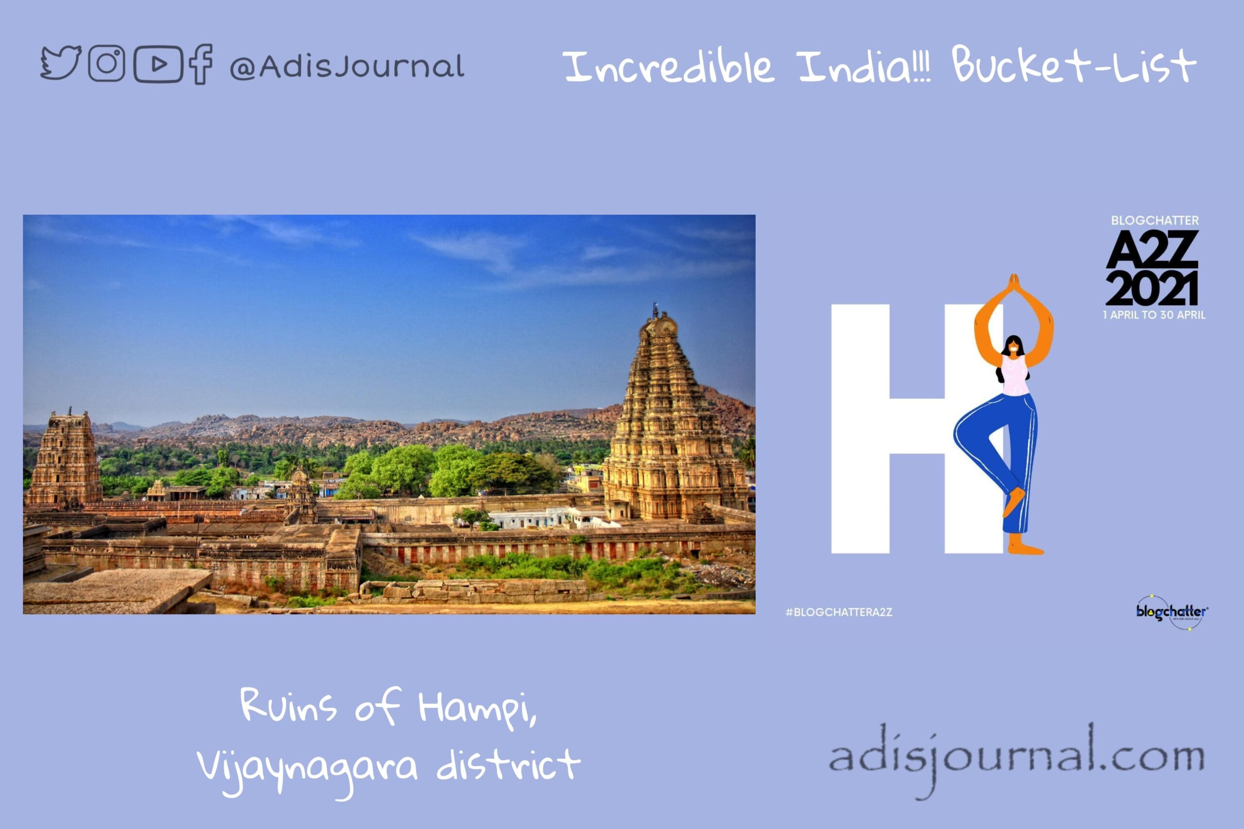
    Ruins of Hampi cover around 4100 hectares. It is near modern day city of Hospet. There are hundreds of spots you can visit and enjoy the glorious carvings, architecture and sculpting from the golden days of Vijayanagara. However, there are few of them which you can’t afford to miss. There are main temples like Virupaksha temple, Achyutaraya Temple, Krishna Temple, Vitthala Temple etc. You can see the ruined market area adjacent to all these temples. In Krishna temple, the shrine of Ugra Nrusinha or Laxmi Nrusinha is one you should definitely check out. Shrine or temple of Nrusinha is a rare thing in India. Garuda Chariot from Vitthala Temple complex is donned with intricate ornate carvings.

    Along with these, there are several hill temple complexes. At some spots, you can reach only if you take a ride on famous Coracles, the circular boat. The Archaeological Museum of Hampi is also a good documentation center. It provides us an idea about the glorious past of the VIjayanagara Empire.


    Today, let’s roam in these ruins and try to imagine the golden days of Hampi when its street used to be bustling with crowded markets.

    This brings to the I am participating in A2Z challenge with Blogchatter and this is my take on day 8 challenge. “H is for the Ruins of Hampi, VIjayanagara District”. You can find my other posts from this challenge here.

  • Fort Kochi ~ a cluster of colonial legacy

    Fort Kochi ~ a cluster of colonial legacy

    India has a very diverse culture with a wide range of languages, landscape and many other things. Along with that, many foreign cultures also mingled and mixed with Indian culture because of the reasons like forced migration, Turkish and Mughal invasions, colonial rule, etc. Today we are visiting a legacy left behind by colonizers on the coast of Malabar. Fort Kochi, a cluster of colonial legacy…

    Story time:

    Water colour painting of Fort Kochi by unknown artist C. 1800

    Back in the days, when the Rajah of Kochi was ruling, a Portuguese ship landed on his shore. Visitors helped the host king in the war with Samoothiri of Kozhikode. To show his gratitude for the help, Rajah of Kochi allowed Portuguese to build the Fort Emmanuel at the coast of Kochi. They settled in and around the Fort and possessed the land for nearly 160 years. They also built a wooden church which was subsequently rebuilt as a permanent structure. That’s today’s  St Francis Church. 

    One legend also talks about a relation with China dating back to the 14th century. When chinese arrived in the region they felt it was like home and called it “Co-Chin” – meaning “Like China”. They installed Chinese fishing nets which are a common site in Kochi. However, local old Malayalam name for the nerve town of Cohin is ‘Maadan-cherry’ or ‘Mattoncherry’

    You can’t miss these in Fort Kochi:

    I remember my childhood visit to Cochin and seeing those gigantic Chinese fishing nets. However, back then, we hadn’t been to this area. Houses here are the mix of Portuguese, Dutch and British architecture credited to the colonial rule of over 3 centuries. St Francis Church is one of the National Monuments. Once it was the burial place of Vasco da Gama. There’s a long walkway along the coast. You will not miss this one pretty unique and iconic site of two rusty steam boilers on this beach.

    However, if you can match the dates of your trip, you definitely should check out the Fort Kochi Biennale started in the year 2012. It is an international exhibition of contemporary art housed in various venues all across area. This COVID-19 pandemic has postponed the fifth edition of biennale twice and is now set to be hosted in November 2021. This could be the best opportunity to visit Fort Kochi and enjoy the colonial vibes of the place if we have cleared through the pandemic.


    For now, let’s stop here for a while before continuing our journey of Incredible India. I will see you tomorrow. Till then, take care and stay safe!

    I am participating in A2Z challenge with Blogchatter and this is my take on day 6 challenge. “F is for the Fort Kochi, Cochin”. You can find my other posts from this challenge here.

  • Edakkal caves: a connection to the ancient world

    Edakkal caves: a connection to the ancient world

    Indian subcontinent witnessed the rise and fall of ancient civilizations. Main action of those civilizations were found in the North-Western parts of the subcontinent in and around Sindhu Valley at locations like Harappa, Mohenjo Daro and Kalibangan etc. Our today’s destination is the proof and the connection to the ancient world dating even further back than Indus Valley civilization. Edakkal caves in Waynad, Kerala are the link between today’s world and the period of Neolithic people. 

    Edakkal caves are ‘rock shelter’ kind of caves. A large boulder is straddling upon a fissure forming these caves. Even the name ‘Edakkal’ literally means ‘a stone in between’.

    Story time:

    As per the legend, Edakkal caves are formed because of the arrows shot by Lav and Kush, sons of Lord Sri Ram. However, credit of the recent discovery of these caves goes to Fred Fawcett, the then Superintendent of Police of the Malabar district. In 1890, he was on one of his hunting trips to Waynad district. He stumbled upon this rock-shelter and discovered it to be the treasure of petroglyphs.

    What’s so cool about it?

    The only site in South India where you can find the petroglyphs carved by Neolithic people. You can reach the caves after a short trek through Ambukutty Mala, a mountain in western ghats. These caves are in the form of two chambers at two levels. The lower is a smaller one with about 210 sq. ft. and 10 m high, while the upper chamber is about 2100 sq. ft. with 18 m high roof.

    Oldest petroglyphs found in these caves are approximately from 6000 BCE. This is a strong evidence of a presence of highly civilized prehistoric settlements in the area. Recently, the State Archeological Department of Kerala conducted a study of the caves in 2009. During this study, they found around 400 signs which depicted the probable connections with Indus Valley civilization. Most important motif found in caves was “a man with a jar cup”. Along with these, there are some engravings in Tamil and Brahmi scripts which are pretty recent in comparison with 8000 years old petroglyphs.


    Let’s appreciate this connection with our very ancient ancestors and halt here for the day. Tomorrow will be one more exciting destination to visit and enjoy. Till then, sayonara…

    I am participating in the A2Z challenge with Blogchatter and this is my take on day 5 challenge. “E is for the Edakkal Caves, Waynad District”. You can find my other posts from this challenge here.

  • Dharur Fort: Gem from an unexplored area

    Dharur Fort: Gem from an unexplored area

    It’s a second leg of our Incredible India!!! bucket-list journey after first Sunday break. Today we are visiting a historic place which stands witness to a very large part of our history. We are visiting an old fort of Dharur (धारूर) which is in Latur district of the state of Maharashtra. This is a gem from a comparatively unexplored area of Marathwada.

    I would like to mention a very amazing treasure trove of information about forts in Maharashtra at the very beginning of this post, TreKshitiZ. You will find very nicely documented, indexed information on their site. I don’t remember when I stumbled upon this site for the first time, but I have been using it at least for a decade now whenever I need any information about Maharashtrian forts. Credit for the photos which you will see in this post goes to them. 

    Story time:

    Back in the days of Satvahanas, Dharur rose to become an important market town on a major road to Satvahana capital city, Paithan. The Rashtrakuta dynasty followed the Satvahanas and ruled the region. Understanding the vitality of Dharur as a market town, they built a fort called “Mahadurg” for its protection. They just piled stones on top of eachother and built battlements and walls. 

    Subsequently, Kalyani Chalukyas, Devgiri Yadavas and Bahmani Sultanate ruled the region. After the fallout of the Bahmani Sultanate in five different factions, this particular region came under the influence of Barid Shah of Bidar. This region witnessed frequent battle action during the volatile period that followed after that. Baridshahi of Bidar succumbed to this volatility, and Adilshah gained control over Dharur. 

    Kishwarkhan from Adilshah court constructed a new fort at the same place of the Mahadurg using stones of the old one in 1567 CE. This is the fort which still stands the ground. Just a couple of years after that, Nizamshah took charge of the place in 1569 CE and in 1630-31, Mughals took control of Dharur. 

    Later it fell in the hands of Nizams of Hyderabad and remained in their control except a brief period of Maratha rule till the accession of Hyderabad principality to the union of India.

    Panorama of Dharur Fort (Photo courtasy: TreKshitiZ)

    What not to miss:

    Dharur Fort has a straight access from Dharur town as both of them are at the same level. However, the fort has a natural protection of the valley from the remaining three sides. This is a very unique combination in itself. 4.2 m wide and 4.5 m deep mote secures the side with straight access.

    There are two walls protecting the fort with battlements at regular intervals to mount the defances. One of the battlements houses the mint started by Mughals. As a memorial to the capture of Dharur fort, they issued a coin. This mint produced Mughal coins for almost the next hundred years. There are two major water tanks with the names of Godi Dindi (गोडी दिंडी) and “Khari/Solapur Dindi” (खारी/सोलापूर दिंडी). There is a dysfunctional “Hamam” with decorative water faucets. We can see a few guard rooms, a couple of mosques, a temple and ruins of various palaces in this fort. Fort also houses a few Percian inscriptions scattered around

    Fort was inhabited till the Indian Independence. As a result of this, it’s in a pretty decent condition. Marathwada region is not famous for tourism but this fort is a gem from this unexplored region. You can stay in the town of Ambejogai or Parali Vaijanath. Both of these are important pilgrimage sites of Hinduism and have good accommodation facilities. Please plan to visit this place and share the word about this.

    Photo courtasy: TreKshitiZ


    Adisjournal or me personally don’t have any claims of copyright over the photos you see in the post. I am a fan and frequent user of a wonderful trekshitiz.com to which these images belong. 

    I am participating in the A2Z challenge with Blogchatter and this is my take on day 4 challenge. “D is for the Dharur Fort, Latur District”. You can find my other posts from this challenge here.

  • Airavatesvara Temple: Magnificent legacy of Cholas

    Airavatesvara Temple: Magnificent legacy of Cholas

    Today, on the 1st of April, we embark on a journey together. It’s a virtual journey to exciting enticing places in our own country, the Incredible India! I have a dream to travel the world. However, I am fortunate to be an Indian. There are so many fascinating places in this country. Every place is attractive because of a unique feature. So, for this year’s April A to Z, I am taking an opportunity to make a sort of bucket list. A list of places to visit in India as soon as we are done with this COVID thing. As it starts with A, the first entry is “Airavatesvara Temple”.

    Airawateshwara temple is at Darasuram, in Thanjavur District of Karnataka. Built by Rajaraja Cholla II, this temple is one of the Great Living Chola Temples. Brihadeshwara Temple at Thanjaur,  Gangaikondacholisvaram Temple at Gadngaikonda Cholapuram are the other two in the group. UNESCO has declared this group of Great Living Chola Temples as a world heritage site.

    Story time:

    Sage Durvasa has cursed Indra’s elephant Airavata to lose its color and beauty for disrespecting him. Upset with guilt and regret, Airavat prayed to Lord Shiva at this temple location. Lord asked him to take a dip in the temple tank. This dip in the temple tank magically restored the color of its skin. After this incident Shiva Lingam at Darasuram bears its present name – Airavatesvara.

    Architecture:

    Rajaraja Chola II built this current complex of Airavatesvara Temple in 12th century CE in a classic example of Dravidian architecture with all of its peculiarities. The whole theme or template follows the Karakkoil style of temples. In this style, the main temple complex is chariot fashioned.  24 m high ‘Vimana’, the towering structure over Garbha Griha, is the pinnacle of architecture of the temple complex. Whole complex is donned with carvings and sculptures of many Vedic and Puranic deities like Indra, Agni, Varuna, Vayu, Brahma, Surya, Vishnu, Saptamtrikas, Durga, Saraswati and many more. 

    Special attraction:

    Additionally, there’s one more interesting thing about this temple. ‘Agra Mandapa’ (अग्र मंडप) has an ornate porch with steps going from east to west with intricately carved balustrades. When one walks on these steps, they produce musical notes. This is the reason for them to be called ‘Singing Steps’. Isn’t it interesting? I have heard about musical pillars in many temples. These singing steps are very fascinating. I am eager to listen to their music.

    So, this is our first stop in this journey. Hope you also find this enticing and plan to visit this architectural marvel soon. Tomorrow, we’ll go to a new place… Till then, sayonara.


    I am participating in A2Z challenge with Blogchatter and this is my take on day 1 challenge. “A is for Airavatesvara Temple, Darasuram, Thanjavur District”. You can find my other posts from this challenge here.

  • पार्टीची स्मारके……….

    बनवली आम्हीही स्मारके लाखो पहा,

    आजची त्या स्मारकांची अवस्था ती पहा..


    मुखी असती घोषणा त्यांच्या जयाच्या,

    मनी योजना स्माराकीच्या पार्टीच्या.