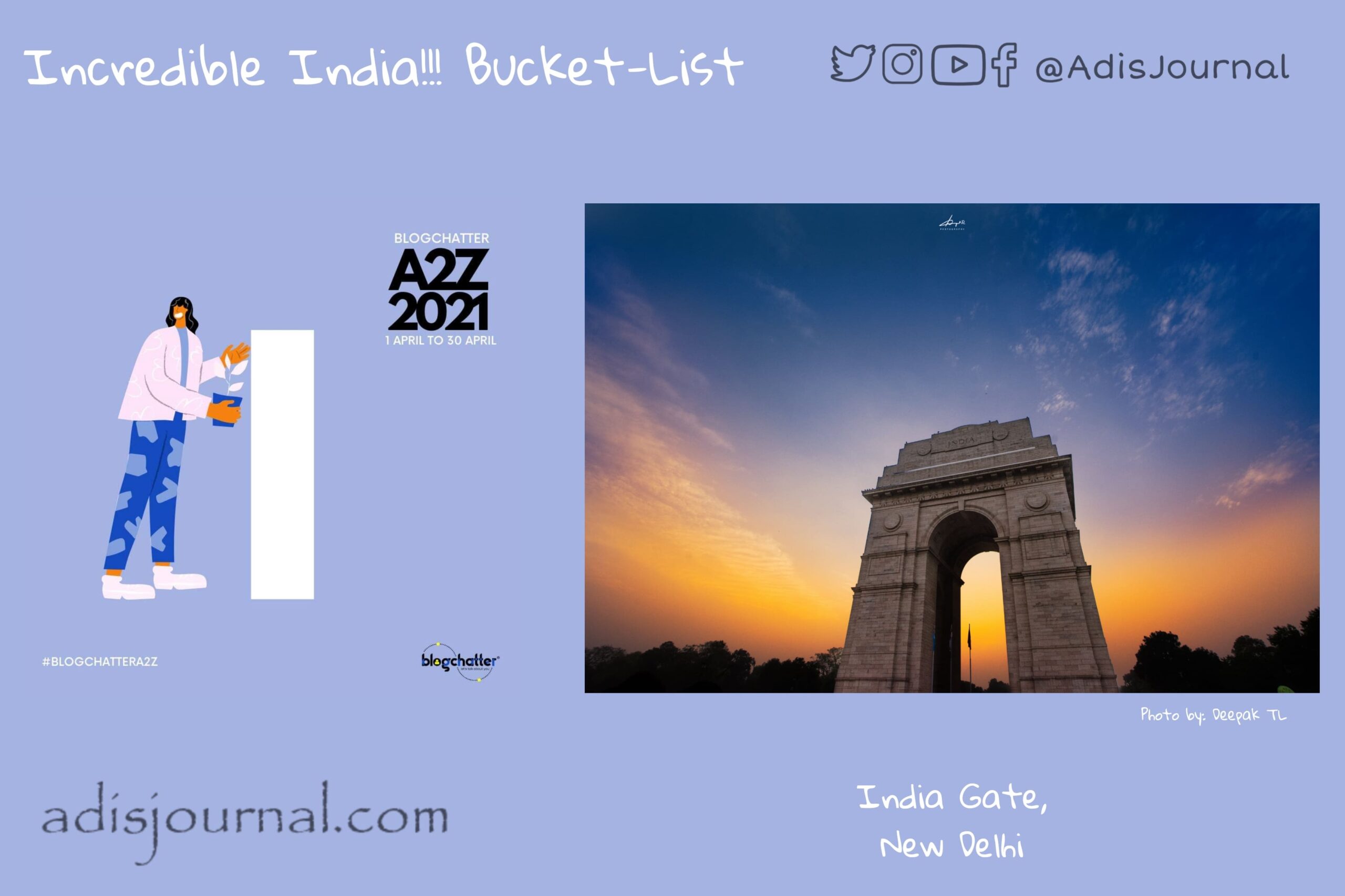
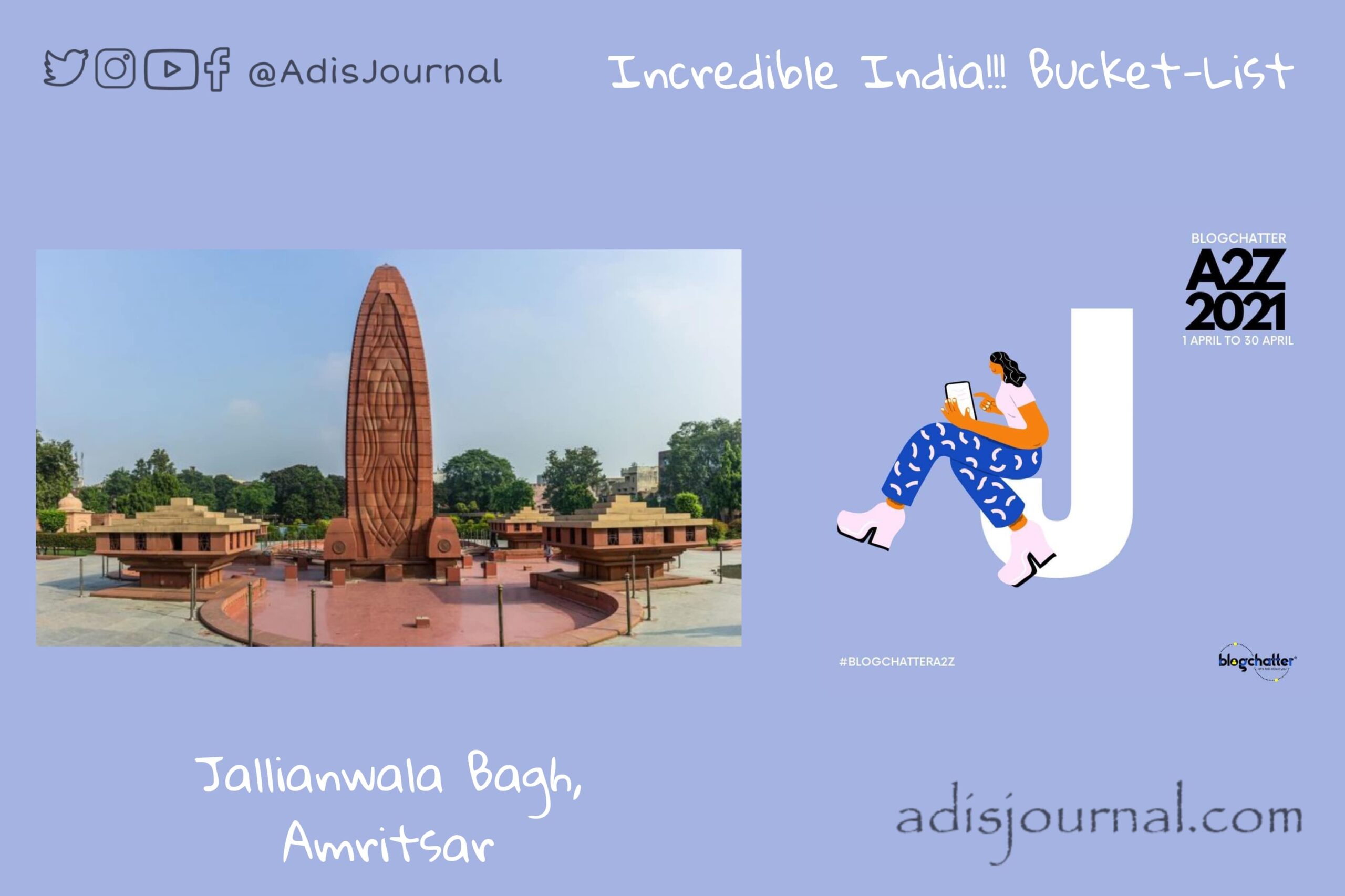
Category: English

  • India Gate: In the memory of fallen heroes

    India Gate: In the memory of fallen heroes

    Indian Armed Forces are our pride. We salute their bravery and chivalry. Their contribution to the nation during war and peace time is unparalleled and unmatched. Before independence, Indian Armed forces were part of British India Army. At every place of deployment they fought bravely and displayed gallantry. Our today’s destination stands in the Capital City of Delhi. India Gate is one of the largest war memorials in India.

    Story time:

    The Imperial War Graves Commission decided to build a memorial to honour the fallen heroes between 1914 and 1921 on various theatres of World War I and the third Anglo-Afghan war. It commissioned Sir Edwin Lutyens to design the memorial. Following his architectural style, Sir Lutyens decided to keep it free of religious ornamentations and make the universal design. He designed the memorial in the form of a hexagonal complex housing a 42 metres tall triumphal arch. He also designed a canopy which once housed a statue of King George V with all imperial symbolisms and few gardens around. 

    India Gate in 1930s

    On both sides you can see inscription of word INDIA. with dates MCMXIV (1914) and MCMXIX (1919) on either side of it. Just below that, following words are inscribed in block letters.

    'TO THE DEAD OF THE INDIAN ARMIES WHO FELL AND ARE HONOURED IN FRANCE AND FLANDERS MESOPOTAMIA AND PERSIA EAST AFRICA GALLIPOLI AND ELSEWHERE IN THE NEAR AND THE FAR-EAST AND IN SACRED MEMORY ALSO OF THOSE WHOSE NAMES ARE HERE RECORDED AND WHO FELL IN INDIA OR THE NORTH-WEST FRONTIER AND DURING THE THIRD AFGHAN WAR'

    India Gate honours 13,218 fallen warriors by their names inscribed on the gate.

    Honouring the post independence war heros

    After the Bangladesh war in 1975, Government of India built Amar Jawan Jyoyi. Reversed L1A1 self-loading rifle capped with war helmet over black marble plinth makes the monument. It has four urns, each with the permanent light from compressed natural gas flames at all four corners of the plinth. It acts as India’s memorial of immortal soldiers. Till recently, on every Republic Day, Vijay Diwas, and Infantry Day, the Prime Minister and the Chiefs of the Armed Forces place wreaths at the Amar Jawan Jyoti.

    Recently, Government built a new National War Memorial and Museum around the canopy. Four concentric circles of monument named as Amar Chakra, Veerta Chakra, Tyag Chakra and Rakshak Chakra, are based on the concept of Chakravyuh war formation. It also houses the second Amar Jawan Jyoti at the centre.

    Hon President Ram Nath Kovind paid tributes at at Amar Jawan Jyoti at the National War Memorial, independence day and republic day. Following the tradition set by Hon President, Prime Minister paid his tribute at the new Memorial on Republic Day.


    If you visit the New Delhi, do not forget to visit and pay tribute to our heroes at these memorials. Let’s all try to be a good citizen worthy for their sacrifices.

    This brings to the I am participating in A2Z challenge with Blogchatter and this is my take on ‘I‘ challenge. “I is for the India Gate, New Delhi”. You can find my other posts from this challenge here.

  • Fort Kochi ~ a cluster of colonial legacy

    Fort Kochi ~ a cluster of colonial legacy

    India has a very diverse culture with a wide range of languages, landscape and many other things. Along with that, many foreign cultures also mingled and mixed with Indian culture because of the reasons like forced migration, Turkish and Mughal invasions, colonial rule, etc. Today we are visiting a legacy left behind by colonizers on the coast of Malabar. Fort Kochi, a cluster of colonial legacy…

    Story time:

    Water colour painting of Fort Kochi by unknown artist C. 1800

    Back in the days, when the Rajah of Kochi was ruling, a Portuguese ship landed on his shore. Visitors helped the host king in the war with Samoothiri of Kozhikode. To show his gratitude for the help, Rajah of Kochi allowed Portuguese to build the Fort Emmanuel at the coast of Kochi. They settled in and around the Fort and possessed the land for nearly 160 years. They also built a wooden church which was subsequently rebuilt as a permanent structure. That’s today’s  St Francis Church. 

    One legend also talks about a relation with China dating back to the 14th century. When chinese arrived in the region they felt it was like home and called it “Co-Chin” – meaning “Like China”. They installed Chinese fishing nets which are a common site in Kochi. However, local old Malayalam name for the nerve town of Cohin is ‘Maadan-cherry’ or ‘Mattoncherry’

    You can’t miss these in Fort Kochi:

    I remember my childhood visit to Cochin and seeing those gigantic Chinese fishing nets. However, back then, we hadn’t been to this area. Houses here are the mix of Portuguese, Dutch and British architecture credited to the colonial rule of over 3 centuries. St Francis Church is one of the National Monuments. Once it was the burial place of Vasco da Gama. There’s a long walkway along the coast. You will not miss this one pretty unique and iconic site of two rusty steam boilers on this beach.

    However, if you can match the dates of your trip, you definitely should check out the Fort Kochi Biennale started in the year 2012. It is an international exhibition of contemporary art housed in various venues all across area. This COVID-19 pandemic has postponed the fifth edition of biennale twice and is now set to be hosted in November 2021. This could be the best opportunity to visit Fort Kochi and enjoy the colonial vibes of the place if we have cleared through the pandemic.


    For now, let’s stop here for a while before continuing our journey of Incredible India. I will see you tomorrow. Till then, take care and stay safe!

    I am participating in A2Z challenge with Blogchatter and this is my take on day 6 challenge. “F is for the Fort Kochi, Cochin”. You can find my other posts from this challenge here.

  • Edakkal caves: a connection to the ancient world

    Edakkal caves: a connection to the ancient world

    Indian subcontinent witnessed the rise and fall of ancient civilizations. Main action of those civilizations were found in the North-Western parts of the subcontinent in and around Sindhu Valley at locations like Harappa, Mohenjo Daro and Kalibangan etc. Our today’s destination is the proof and the connection to the ancient world dating even further back than Indus Valley civilization. Edakkal caves in Waynad, Kerala are the link between today’s world and the period of Neolithic people. 

    Edakkal caves are ‘rock shelter’ kind of caves. A large boulder is straddling upon a fissure forming these caves. Even the name ‘Edakkal’ literally means ‘a stone in between’.

    Story time:

    As per the legend, Edakkal caves are formed because of the arrows shot by Lav and Kush, sons of Lord Sri Ram. However, credit of the recent discovery of these caves goes to Fred Fawcett, the then Superintendent of Police of the Malabar district. In 1890, he was on one of his hunting trips to Waynad district. He stumbled upon this rock-shelter and discovered it to be the treasure of petroglyphs.

    What’s so cool about it?

    The only site in South India where you can find the petroglyphs carved by Neolithic people. You can reach the caves after a short trek through Ambukutty Mala, a mountain in western ghats. These caves are in the form of two chambers at two levels. The lower is a smaller one with about 210 sq. ft. and 10 m high, while the upper chamber is about 2100 sq. ft. with 18 m high roof.

    Oldest petroglyphs found in these caves are approximately from 6000 BCE. This is a strong evidence of a presence of highly civilized prehistoric settlements in the area. Recently, the State Archeological Department of Kerala conducted a study of the caves in 2009. During this study, they found around 400 signs which depicted the probable connections with Indus Valley civilization. Most important motif found in caves was “a man with a jar cup”. Along with these, there are some engravings in Tamil and Brahmi scripts which are pretty recent in comparison with 8000 years old petroglyphs.


    Let’s appreciate this connection with our very ancient ancestors and halt here for the day. Tomorrow will be one more exciting destination to visit and enjoy. Till then, sayonara…

    I am participating in the A2Z challenge with Blogchatter and this is my take on day 5 challenge. “E is for the Edakkal Caves, Waynad District”. You can find my other posts from this challenge here.

  • Dharur Fort: Gem from an unexplored area

    Dharur Fort: Gem from an unexplored area

    It’s a second leg of our Incredible India!!! bucket-list journey after first Sunday break. Today we are visiting a historic place which stands witness to a very large part of our history. We are visiting an old fort of Dharur (धारूर) which is in Latur district of the state of Maharashtra. This is a gem from a comparatively unexplored area of Marathwada.

    I would like to mention a very amazing treasure trove of information about forts in Maharashtra at the very beginning of this post, TreKshitiZ. You will find very nicely documented, indexed information on their site. I don’t remember when I stumbled upon this site for the first time, but I have been using it at least for a decade now whenever I need any information about Maharashtrian forts. Credit for the photos which you will see in this post goes to them. 

    Story time:

    Back in the days of Satvahanas, Dharur rose to become an important market town on a major road to Satvahana capital city, Paithan. The Rashtrakuta dynasty followed the Satvahanas and ruled the region. Understanding the vitality of Dharur as a market town, they built a fort called “Mahadurg” for its protection. They just piled stones on top of eachother and built battlements and walls. 

    Subsequently, Kalyani Chalukyas, Devgiri Yadavas and Bahmani Sultanate ruled the region. After the fallout of the Bahmani Sultanate in five different factions, this particular region came under the influence of Barid Shah of Bidar. This region witnessed frequent battle action during the volatile period that followed after that. Baridshahi of Bidar succumbed to this volatility, and Adilshah gained control over Dharur. 

    Kishwarkhan from Adilshah court constructed a new fort at the same place of the Mahadurg using stones of the old one in 1567 CE. This is the fort which still stands the ground. Just a couple of years after that, Nizamshah took charge of the place in 1569 CE and in 1630-31, Mughals took control of Dharur. 

    Later it fell in the hands of Nizams of Hyderabad and remained in their control except a brief period of Maratha rule till the accession of Hyderabad principality to the union of India.

    Panorama of Dharur Fort (Photo courtasy: TreKshitiZ)

    What not to miss:

    Dharur Fort has a straight access from Dharur town as both of them are at the same level. However, the fort has a natural protection of the valley from the remaining three sides. This is a very unique combination in itself. 4.2 m wide and 4.5 m deep mote secures the side with straight access.

    There are two walls protecting the fort with battlements at regular intervals to mount the defances. One of the battlements houses the mint started by Mughals. As a memorial to the capture of Dharur fort, they issued a coin. This mint produced Mughal coins for almost the next hundred years. There are two major water tanks with the names of Godi Dindi (गोडी दिंडी) and “Khari/Solapur Dindi” (खारी/सोलापूर दिंडी). There is a dysfunctional “Hamam” with decorative water faucets. We can see a few guard rooms, a couple of mosques, a temple and ruins of various palaces in this fort. Fort also houses a few Percian inscriptions scattered around

    Fort was inhabited till the Indian Independence. As a result of this, it’s in a pretty decent condition. Marathwada region is not famous for tourism but this fort is a gem from this unexplored region. You can stay in the town of Ambejogai or Parali Vaijanath. Both of these are important pilgrimage sites of Hinduism and have good accommodation facilities. Please plan to visit this place and share the word about this.

    Photo courtasy: TreKshitiZ


    Adisjournal or me personally don’t have any claims of copyright over the photos you see in the post. I am a fan and frequent user of a wonderful trekshitiz.com to which these images belong. 

    I am participating in the A2Z challenge with Blogchatter and this is my take on day 4 challenge. “D is for the Dharur Fort, Latur District”. You can find my other posts from this challenge here.

  • Rights of Rivers

    Rights of Rivers

    Today is 14th March and since 1997, it is observed and celebrated as an International Day of Action for Rivers. Participants from 20 countries attending the first International Meeting of People Affected by Dams, decided on this date to unite to conserve and protect rivers, other water bodies and watersheds against destruction. This year, we are celebrating this day with the theme “Rights of Rivers”. Today when we are equipped with cutting edge technology and engineering, we think we can command the forces of nature to do our bidding. We have encroached too much on nature and ignored their rights. Rights they have because of the might of beastly forces they possess. This perceived supremacy over nature has blinded us and we keep encroaching more and more upon the Rights of Rivers and streams. However, the culture of the Indian subcontinent was not like this before.

    Described as सुजलां सुफलां in our national song वंदे मातरम् by Bankimchandra Chattopadhyay, India is the Land of Plenty. Northern Himalayin perennial rivers like Ganga, Sindhu and Yamuna, uniquely west bound river Narmada; Godavari and Krishna as lifelines of Maharashtra and Telangana; Kaveri of Karnataka and Andhra along with colossal Brahmaputra have given this quality to this subcontinent. Over the thousands of years, these mighty rivers gave birth to many civilizations along their banks with the constant flow of life between their origin and mouth. We consider our rivers as Goddesses and worship them every evening with a pomp in many cities. Ganga Aarti from Varanasi and Prayag is a very famous event.
    Right from the Sindhu Civilization of Harappa, Mohenjodaro and hundreds of other settlements to today’s modern cities of India, we are totally dependent on this constant flow of life. With the progress and development of civilization, humans started bending the forces of nature to their convenience. It curbed the Rights of Rivers. We dammed the constant flow of life

    What are the Rights of Rivers?

    I believe there are two very basic rights which rivers have carved themselves, in literal and figurative sense.
    First is to “flow continuously” from its origin in hills to the mouth to meet the sea and second is the “Right of Way” between the banks which it has carved itself by flowing for thousands of years.

    Settlements started to grow on the banks of rivers as they were a source of water for all human activities like agriculture and industries along with household consumption. Increased urban population leads to the surge in water demand. Cities started looking for surety of water supply. Many rivers in India are not perennial as they are solely dependent on monsoon for the water. We started constructing dams to solve this problem and assure the constant water supply. As of the beginning of 2021, India has over 5700 large dams across the country. There are many more small dams and barrages scattered all over the country.

    The flow of water in the rivers is almost zero as every city tries to hold almost all the water in the dams to cater to the ever increasing demand of the city. For example, Mutha River in Pune sadly now carries only sewage that is coming from the STPs of the city. Khadakwasla dam does not release any water in the river unless it is full in the monsoon days. As a result, there is no water flowing in the river. The natural ecological stability of the downstream region depends on flowing water in the river. Even The Krishna Basin Tribunal has ordered 6 cusecs of constant water flow in the river. However, the ground reality is a complete contrast to the order.

    Mula River. Photo Source – CDSA

    Giving the “Right of Way” is the right way

    Rivers and streams flow between the two banks which are carved by the river itself. Rivers undergo waxing and veining as seasons change throughout the year. This is another important Right which rivers have carved for themselves. During monsoon, with the heavy rainfall in upstream catchment areas, rivers do come out the banks and inundate the plains which are above the banks. We call this phenomenon “flood.” There are regulations in urban areas to deter the construction and occupation of the floodplains to avoid the loss of life and property if flood occurs. Flood zones are marked with probability analysis of possible inundations in case of high floods. These flood zones are no development zones. However, lawmakers considered the definition of the River and River Channel “no brainer” and did not formulate it when they created these rules and laws.

    These two things have created a loophole in development controls and Indian cities are witnessing a huge encroachment in the river and flood zones. Small streams are the feeder networks of the rivers. They are literally murdered by dumping debris into and constructing upon them. The chain of River ecosystems in its watersheds is broken with the loss of these streams. As a result, Indian cities are facing devastating effects of broken ecosystems. One part of the country faces urban flooding with short bursts of heavy rainfall. While there is a drought in the other parts of the country at the same time. The Mumbai floods of 26th July 2005 was the first alarming event from the chain and since then it is happening in one city or the other regularly. Surat, Chennai, Bangalore, Kedarnath (Uttarakhand), Kashmir. List goes on. Every monsoon, the list gets longer and longer.

    Honoring the Rights of Rivers

    To sustain human settlements and live a good life we should start respecting the rights of rivers. As a common citizen, we should stop polluting the rivers by our personal actions. We should create an awareness for banks of rivers and streams to be the sacrosanct Right of Way.

    Let us join our hands and think about the rivers as trustees tasked with taking care of them for our future generations and protecting Rights of Rivers.


    Adi’s Journal
    Feb 2021


    This post is part of Blogchatter’s CauseAChatter

  • Environment: What does that even mean?

    Environment: What does that even mean?

    What do we think when we hear, read or talk about the word “Environment”? The picture we paint of the environment is of lush green forests, clean and flowing rivers, hills and mountains free from plastic and other waste, pollution free oceans and clean air. However, we conveniently ignore that all parts of the earth are not supposed to be covered with lush green forests. Some might be barren with fine sand and scattered thorny shrubs, or vast grasslands without any sight of large trees for acres and acres. The landforms and the flora-fauna they support come in a variety of packages. These are governed by the geo-climatic conditions of the region. Let’s look at the components of the environment.

    Components of Environment

    Components

    Environment is a pretty large umbrella term. It comprises all the natural features which we can observe on the earth, under rivers and oceans and other water bodies, in the atmosphere surrounding the Earth. It also comes with some underground features like ground water, fossil fuels and other mineral deposits. But, this is an incomplete list of environmental components. We always tend to forget that humans are very much a component of this environment. Thankfully, the time of denial has passed. Now globally we are ready to at least recognize the adverse impacts of our actions which are leading to increased rates of global warming.

    Few steps are being taken to reduce these impacts. Some frameworks have been established to monitor or amend some wrong doings. The United Nations Development Programme has come up with 13 Sustainable Development Goals (SDGs). India is a signatory nation to SDGs. Similarly, State Governments have drafted policies and decided the goals to achieve.

    For urban areas in India, all the local governments have to prepare and table the annual Environmental Status Report (ESR) as per the 74th Constitutional Amendment Act.

    This report should act as the base for the city’s policy to take a step towards sustainability. But if we look at the reports, we can observe that the granularity of data and the scope of environmental indicators keep on varying from city to city. Very rarely we get any actionable suggestion or plan in these reports. Almost every city has ignored the data about one common parameter the Built Environment is ignored

    What is a Built Environment?

    Built Environment is a major component of urban areas. It covers all the buildings, amenities, services and infrastructure created to have a good quality of life in urban areas. ESR should be certainly prepared incorporating indicators about the built environment. Centre for Development Studies and Activities (CDSA), Pune has created a framework data ecosystem which enables the recording and analysis of the data on the indicators of the built environment in urban areas and strongly advocates the significance of the “Built” component of the Environment umbrella. One cannot ignore this component when the aim is to achieve Sustainability

    In many ways, the built environment is the manifestation of our good and bad practices. It represents unsustainable and polluting materials that might be used for construction but also natural, environmentally safe materials.

    CDSA has initiated a movement for public participation called Quantified Cities Movement. The movement engages us in observing and safeguarding urban quality of life. Movement works as a catalyst in spreading awareness about various aspects of quality of life and environment. Please do join the movement and understand our environment better and in a holistic way.


    This post is part of Blogchatter’s CauseAChatter

    ~~~
    Adi’s Journal
    Feb 2021